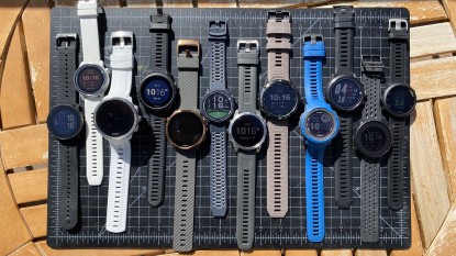
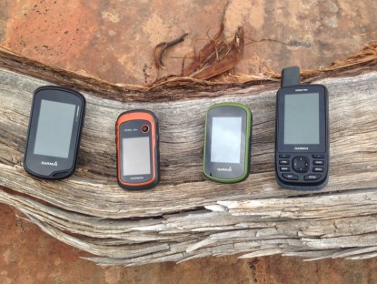
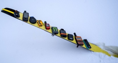
We have invested a great deal into covering a broad portion of the entire market of compact outdoor electronics — handheld GPS units are no exception. Along our journey, we have learned what to look for, and what key components should be emphasized for certain pursuits.
In the "information age", outdoor enthusiasts and athletes are looking to better track and monitor their adventures. Whether in the deep wilderness or on your neighborhood streets, effective navigation and communication is crucial. An outdoor enthusiast has a whole host of choices and information to sort through in making his or her selection of the best handheld GPS units available on the market today.

Background and Terminology
Most tracking and navigation devices in this country use the Global Positioning System (GPS). GPS is a network of satellites maintained by the US Government, each of which is constantly sending a simple signal toward earth. The two other major, similarly designed systems are the Russian GLONASS (GLObal NAvigation Satellite System), and the European Union's Galileo network.

A device on the ground senses these signals and, measuring their relative strength, can determine one's position on the earth. From that position data location, speed, prior position, distance, and direction to a future position can be deduced. GPS requires open sky and significant battery power.

Other devices — like the Garmin inReach Explorer+ — use one of another few satellite networks for one- or two-way routine and emergency communication. Where cellular phone signal is inadequate or completely missing, tapping into these satellite communication networks allows for effective discourse. This function is useful both for requesting help in emergencies, non-emergency help (broken down car, e.g.), and communicating with basecamp or loved ones.

A select few devices use barometric pressure sensors to deduce weather changes and altitude. Additionally, some of these higher-end models can connect to a smartphone and provide real-time weather updates. While smart notifications are less common, many of the handheld GPS units in this review have wireless capability for transfer of information via Bluetooth.
Recommendations by Activity
While there certainly is a lot of crossover, certain handheld GPS units are much more suited to certain activities. Some activities — like driving — are best served by very specific types of equipment, while certain sports — like alpine climbing — might be better served by a GPS unit with different features. Keep in mind that many smartphone apps essentially perform the same function as a GPS, but will often don't offer the same capability in terms of durability and battery life.
Driving
The most daily application of a portable GPS is in the car. While there are plenty of road-adapted options on the market, you may want a more versatile handheld GPS unit that can pull double duty on- and off-road. The most important characteristic to look for in a road-worthy GPS will be auto-routing — the ability to adapt to your most recent movement, and update your route accordingly. Otherwise, we prefer to opt for devices that have larger screens so that we can gather information easily at a glance. A touch screen is also a nice feature, but not as necessary. Most of the units we tested have a spine capable of mounting to the dashboard of a car, and only require the purchase of a mount to pull them into this capacity. Unfortunately, most of the handheld GPS units will not have audible prompts like driving-specific units — this makes them a little less practical, but overall, still a more resourceful purchase.

Cycling
For hard-core cyclists, particularly touring cyclists and bikepackers, long trips almost require the navigation capability of a GPS unit. Similar to driving, most handheld GPS units are designed with spines that are compatible with handlebar mounts. Seek out a device that has a large screen for easy high-speed viewing, and tracks relevant data, like speed, distance, and vertical feet. For ease, look for a model that comes preloaded with detailed maps and can provide turn-by-turn navigation. If you also run or climb and want to own a device that works for cycling too, maybe opt for a model that is more compact. They may have smaller screens, but are often lighter. With aftermarket handlebar mounts and an app like Strava your smartphone can also be pressed into cycling service, though it will be very limited in terms of battery life. As a cycling tracker, smartphones work alright, but dedicated equipment is more weatherproof and allows you to keep your phone on your body for music and security.

Running
In our experience, only long-distance trail runners opt for GPS units. While it is possible to carry a handheld unit like the ones in our review, more than likely runners will opt for a GPS watch, rather than one that you have to keep in your pocket. Just like with bicycling, the user can track his or her running with a smartphone and appropriate app almost as easily as a GPS-specific watch.

Hiking and Backpacking
Expensive off-trail navigation in the burliest of conditions is the bread-and-butter of a handheld GPS unit. Thanks to their admirable battery life, large screens, and very accurate sensors across the board, we would recommend nearly every model in our review for this activity. Weather is certainly a factor to consider, and if you live in a wet climate or often go winter camping, we would suggest a device with buttons rather than one with a touchscreen that has the potential to fail in austere environments. It's is becoming more and more standard for hikers to carry some sort of satellite locator beacon in the wild so they can be found in the event of an emergency. For hikers who don't typically go on long trips, or rarely go off trail, a smartphone app like Gaia or Topo Maps can suffice. But remember, your smartphone may not be as durable or weather resistant as a dedicated GPS unit.

Rock and Ice Climbing
Rock and ice climbers, especially those with more athletic motivations as opposed to self-proclaimed "adventure climbers", are generally unaccustomed to carrying electronics with them. This is apt to change as the demographics of climbers change and as the availability and portability of relevant technology improves. First of all, because of the seriousness of the climbing setting, all climbers should at least consider some sort of emergency communication. In many cases a cell phone is appropriate, but in others users should consider a personal locator beacon. If you don't want to splurge for a PLB, a simple, handheld GPS unit may just be the ticket to help navigate your walk-off descent. While it would be useful on the ascent as well in some alpine-cases, GPS data is notoriously unreliable on steep cliff sides.

Mountaineering
Mountaineering combines many of the concerns of rock and ice climbing with those of hiking and backpacking. Many will want to track their speed, altitude, and distance. Many will need assistance with navigation. In steep mountaineering settings, GPS altitude data is poor, and retrieving a handheld GPS device from a pack or pocket can be problematic. But for multi-day outings, having a handheld unit that includes a barometric altimeter might afford more accurate vertical position data. High-end models with barometers are also capable of sending weather alerts, a life-saving function if you are in a position where you can't readily see an approaching storm. Of course, since mountaineering takes place in remote areas, we recommend at least considering some sort of satellite beacon for emergency communication as well. While it isn't always necessary, mountaineers should always consider bringing avalanche safety equipment, including an avalanche beacon, and the effect of a GPS unit should be considered on the function of that lifeline.

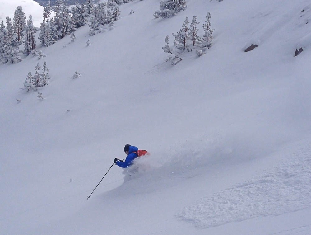
Backcountry Skiing
Backcountry skiing is much like mountaineering — the setting is steep, remote, and inherently off trail. Choose your electronic accompaniment accordingly. Our recommendations for backcountry skiing are basically the same as for mountaineering, with one important caveat that we briefly mentioned above. In mid-winter backcountry skiing, the main threat is often snow avalanches. This necessitates safety training and equipment including a transceiver but also requires giving consideration to electronic interference. Transceivers are vulnerable to the interference of nearby electronics. Adding more and more devices to your body and pack adds more risk that your avalanche beacon will malfunction when you most need it. Pick the transceiver first, and add just the most necessary others.
Water Sports
For river, lake, and coast travel a GPS device that can be mounted are most useful. On a river or lake, conditions can change quickly, so a device that can provide weather updates and link that information directly to your phone can come in particularly handy. At the very least, a barometric altimeter on your handheld device helps predict storms and weather conditions. Having accurate topo maps and good tracking functions are helpful to make sure you know when to expect things like rapids and campsites, and can also help roughly gage flow rates. Look for units that have excellent water resistance, take note of the IP rating and overall durability of a GPS unit.

Expedition Travel
For extended remote travel, we are definitely carrying a GPS unit to supplement our maps, and often as a back-up should we get caught out in nasty weather. In order to keep all those devices powered up, we have evaluated the best solar chargers and external USB battery packs, which are turning out to be indispensable gadgets on their own to supplement the nearly required handheld GPS and/or PLB devices.